|
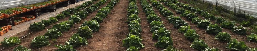
Satellite technology could help us start to reverse the perilous condition of our soils… 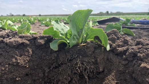 © Photo by Lizzie Sagoo, ADAS There is a growing crisis underfoot. Our soils – vital to both our ecosystems and agriculture – are degrading at an unprecedented rate, due to factors that include intensive farming, deforestation and pollution. Degraded soils directly affect food security, availability of clean water, global warming mitigation efforts and biodiversity. But it is difficult to know where to begin to address the issue whilst we lack the technology to accurately monitor soil health on a large scale. Thanks to this ambitious new project from the STFC Food Network+, we could soon be using technology from the space sector to shine a light on the state of our soils.
“There is currently a real gap in our knowledge when it comes to monitoring soils on a large scale” says soil scientist Marcelo Galdos (University of Leeds). “Currently, soil analysis typically involves taking a sample at a discrete location and sending it to a laboratory. At a large scale, this would be expensive and highly labour intensive”. Working with collaborators through the STFC Food Network+, Marcelo is developing a proposal for a completely new approach, using remote satellite imaging and biogeochemical modelling. “For this project, we are focusing on estimating soil organic carbon, as this is a proxy for overall soil health” he says. “It indicates the rate at which the soil is being degraded and its ability to produce food or provide ecosystem services, such as purifying water and removing CO2 from the atmosphere”. Consequently, determining soil organic carbon by integrating satellite data, modelling and field measurements could provide an instant map of UK soil health, complementing ‘on the ground’ surveys. To begin, Marcelo and his colleagues are scoping all the possible ways that satellite data could potentially be used, to produce a shortlist of the most promising approaches. These include using remote sensing to estimate soil temperature, soil moisture levels, land use and land cover, and aboveground biomass. Combining these quantitative measurements with field-scale data could demonstrate how different land uses or crop types affect soil health. “This could even be extended to compare the impact of different soil management systems, such as no-till techniques, cover crops and crop rotations” says Marcelo. If data was collected over a time series, this could even show how the timings between tilling, planting and harvest affect soil quality. All of this valuable data could ultimately feed into policies to support the UK Government’s 25-year Environment Plan, which aims to incentivise farmers to improve vital ecosystem services, including soils. It could also prove crucial in our ongoing battle against climate change. “Achieving net-zero will only be possible if we both reduce emissions and remove carbon from the atmosphere” Marcelo says. An accurate map of UK soil condition would enable high-carbon areas, such as peatland, to be preserved and also identify regions where soil carbon could be improved through better management techniques. Clearly, the potential benefits of this project are significant, but it can only succeed with input from a wide range of disciplines – from soil scientists and agronomists, to satellite experts and climate modellers. Indeed, Marcelo had first thought about using satellites to monitor soils several years ago, but the catalyst for the project came when he attended the STFC Food Network+ Sandpit Event ‘Adapting to climate change: climate-smart agriculture’ in March 2019. It was here he met his future collaborators, Lizzie Sagoo (ADAS, an environmental consultancy), Daniel Morton (UK Centre for Ecology and Hydrology) and Martin Hardcastle (University of Hertfordshire). Since then, the network has grown exponentially, resulting in a workshop in September 2019 attended by experts in a wide range of fields. “This had a truly multidisciplinary and even international reach, including participants from Brazil, the US and Norway, besides start-up companies that use satellite data, such as SatSense” says Marcelo. “Talking with so many different people really helped to formulate our ideas”. Once these techniques have been refined, they could potentially be applied to sensors on drones, opening links to precision agriculture, where inputs (e.g. fertilisers and pesticides) are only applied where and when needed. Ultimately, Marcelo believes major benefits could be realised by this combination of modelling and remote sensing in developing countries, or in his home country of Brazil. “During my early research years, I spent time in Africa researching sustainable agricultural techniques, and I am currently involved in a large project on climate-smart agriculture there. I would really like to apply this approach to support climate change adaptation and mitigation strategies globally” he says. In the meantime, the challenge of mapping the UK’s soils is enough. And when he’s not at work, Marcelo turns his attention to the soils around his home. “As a soil scientist, perhaps it is not surprising that I am a keen gardener!” he jokes.
0 Comments
Your comment will be posted after it is approved.
Leave a Reply. |
AuthorJune 2024 - Archives
June 2024
Categories |

- Home
- Webinars and Events
- About the SFN+
- News
- Blog
- Expert Working Groups
- Funding
-
Publications
- Bioeconomy positioning paper
- SFN+ 5th Annual Conference
- OMM Policy Report
- ‘Multi-Stakeholder International One Day Workshop on Organic Agri-Food Value Chains for Net Zero’ Report
- SFN 2050 UK Net Zero Food report
- Sustainable Cold Food Chain Booklet
- Food Sensing Technologies for Safe and Nutritious Food
- Sustainable urban and vertical farming
- Projects
- Join/Contact Us
 RSS Feed